Key Finding
Twice a year debates erupt across the continental United States: should we keep Daylight Savings Time (DST) or leave it behind forever? The only preference with widespread agreement is against changing clocks, one way or the other. Perhaps all of the participants in this perennial argument have a common opponent: not each other, but the time zone lines as they are currently drawn.
Keeping Daylight Savings year-round would bring unreasonably late sunrises in Detroit and other cities in the Northwest corners of our current time zones, creating morning traffic hazards for pedestrians. But Standard Time brings winter sunsets before 5 p.m. across the time zones’ eastern edges, with equally dangerous results.
This map aims to fix both of these problems. It draws on earlier work including cartographer Andy Woodruff’s “Daylight Savings Time Gripe Assistant Tool,” which invites users to explore schedules that would best fit their preferences for sunrise and sunset times. It also draws on maps of metropolitan areas and tribal lands, to keep them unified and possibly solve current intra-state complications in the process.
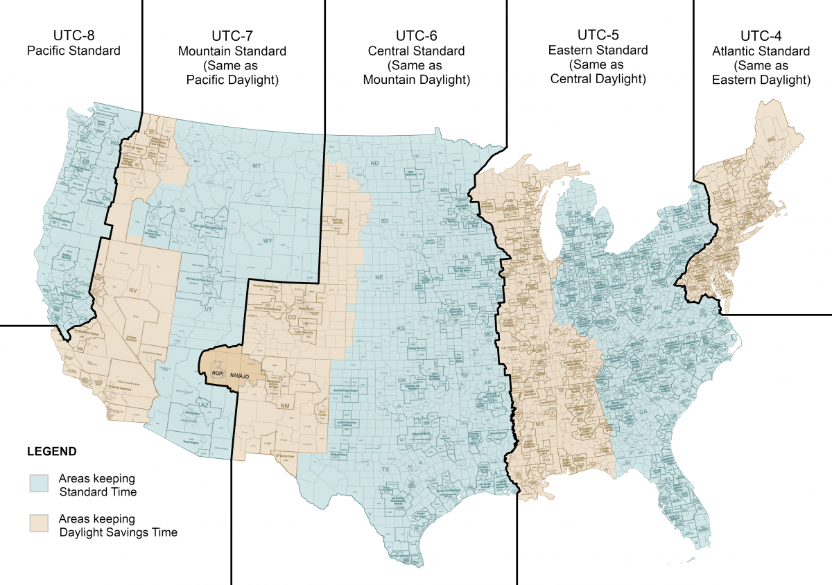
This effort follows state boundaries where possible, but also recognizes that even more important than state boundaries are the boundaries of metropolitan statistical areas (MSAs). The metro areas surrounding cities such as Chicago, St. Louis, and Washington, DC cross state boundaries, as do their commuters every day. To avoid splitting MSAs, this map occasionally opts to split some states instead. Whereas 12 states in the continental United States are currently divided with time zone differences, this proposal includes 13 such splits. For example, western Pennsylvania is placed in Central Time to optimize sunrise and sunset times, but southeastern Pennsylvania belongs with the Northeastern Megalopolis of Philadelphia, New York, and New Jersey.
The same is true for the Pacific Northwest. From Seattle to San Francisco, the MSAs are more connected to each other than they are to the eastern parts of their states. To ensure reasonable sunrise times for these cities while respecting interstate MSAs such as Spokane, it divides Washington, Oregon, and California. The time zone boundary across California is chosen based on current MSA boundaries, which divide Fresno and San Francisco, as reflected in the recent proposal to split California into multiple states.
As sovereign nations, Native tribes have the prerogative to choose their time zones and schedules. For example, the Navajo Nation overlaps Arizona—which does not recognize DST—as well New Mexico and Utah, which do. The Navajo Nation opts to recognize it, while the Hopi Nation—enclosed within Navajo lands in Arizona—does not. This situation creates a summer “time donut” in which Hopi lands are on a different schedule from the Navajo lands surrounding them, which in turn are on a different schedule from Arizona.
The choice to place the Navajo Nation in Central—rather than Mountain—Standard Time is based on the current choice of the Navajo Nation to be on the same schedule as New Mexico. However, either the Navajo or Hopi Nation—or both—may prefer to remain on an Arizona time. If the Navajo Nation prefers to remain with New Mexico while the Hopi prefers to remain with Arizona, then the Arizona time donut will remain.
This map is presented as a starting point for discussion toward finding a schedule that can work for everyone year-round.

Rebecca Ray is a Senior Academic Researcher at the Boston University Global Development Policy Center. She holds a PhD in Economics from the University of Massachusetts-Amherst and an MA in International Development from the Elliott School of International Affairs at the George Washington University.