download the brief
Key Findings


New Hampshire’s ocean coastline, though small relative to that of other states, is a place where people have lived, worked, and died for thousands of years. It is home to numerous important cultural heritage sites,1 and its identity is tied in tangible and intangible ways to centuries of marine-based ways of life.2 Tourism to the region’s remnant historic heritage sites and cultural landscapes is a key factor in coastal New Hampshire’s strong demographic, social, and economic growth. Rockingham and Strafford, the state’s two coastal counties, accounted for $104.7 million, or well over a third (37.5 percent), of the state’s meal and room tax revenue in fiscal year 2014.3
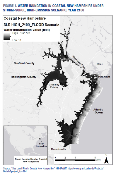
Coastal New Hampshire has been identified by scientists and recognized by policy makers as an area experiencing many of the effects of climate change, including increasing temperatures and rising sea levels (Figure 1). The continued trajectory of such change places the seacoast region at a very high risk of coastal flooding today and of coastal land submersions within the next 50 to 100 years.4 This means that on the New Hampshire seacoast, as with coastal areas across the globe, culture heritage sites are going to be damaged and/or destroyed as seawater moves inland.5 The data summarized in this brief show that coastal New Hampshire has the potential to lose up to 14 percent of its known prehistoric (ca. 8000 BC to 1500/1600 AD) and historic (ca. 1500/1600 AD to 1900 AD) cultural heritage sites to sea-level rise. In addition, over 80 known historic cemeteries are at risk for damage or complete destruction.
While the situation is critical, there is no straightforward path for addressing it. Communities across the region will have to grapple with hard realities and complicated decisions as cultural heritage sites and cemeteries begin to, quite literally, wash away.
Analyzing Cultural Heritage Vulnerability in Coastal New Hampshire
Climate Solutions New England, a public-private partnership based out of the University of New Hampshire Sustainability Institute, modeled six sea-level rise (SLR) scenarios for coastal New Hampshire using a variety of data sources, including tidal gauges, historic flood and temperature records, and detailed light detection and ranging (LIDAR) terrain maps. The six scenarios include three regular (non-storm-surge) impacts—a high-emission pattern at year 2050, a high-emission pattern at year 2100, and an intermediate-emission pattern at year 2100—and three storm surge imparts for the same patterns.6 For each scenario, Climate Solutions produced an image that demonstrates what areas are prone to flooding and water-over-land submersion. Figure 1 illustrates the “worst-case” scenario—high emission rates and storm surges in year 2100.
To assess the vulnerability of cultural heritage sites to sea-level rise, I overlaid the locations of 383 prehistoric and historic sites in Strafford and Rockingham counties onto maps depicting each of the six SLR scenarios7 and computed the value of the depth of water inundation for each site. Sorting sites by this value for each scenario allowed for the identification of a range of vulnerability of heritage sites to destruction by sea-level rise.8 The pie charts in Figure 2 illustrate what percentage of known cultural heritage sites will be lost in each SLR scenario.
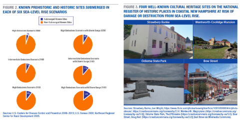
Under every scenario, known cultural heritage sites in Strafford and Rockingham will be affected by sea-level rise and associated storm surges. In the lowest-impact scenario, 5 percent of currently known sites will be affected; in the highest scenario, 14 percent will be affected, with many experiencing complete water inundation. It is of particular concern that in every possible scenario sites on the National Register of Historic Places (the official list of the nation’s historic places worthy of preservation) will be affected9; in the worst case (high emissions with storm surge, year 2100), twelve sites on the National Register will be affected (Figure 3). These twelve sites include many key heritage tourism destinations in the seacoast, such as the Strawbery Banke Historic District/Museum and the Wentworth-Coolidge Mansion. Odiorne State Park, a popular tourist draw for both natural and cultural heritage reasons, will be affected in four scenarios. Additionally, Portsmouth’s Historic District, which was added to the National Register of Historic Places in 2017, is vulnerable. Bow Street, which is central to the historic district and hosts numerous shops, bars, and restaurants appealing to tourists, will be inundated under every scenario.
The database of known prehistoric and historic heritage sites does not include historic cemeteries (only known prehistoric burial sites are included). Yet, historic graveyards are a common feature of the cultural heritage landscape of New England. By working with a spatial database (produced in 2000) which digitized New Hampshire Old Graveyards Association records,10 I computed values for water inundation for mapped historic graveyards in Rockingham and Strafford counties under the worst-case SLR scenario.11 This computation finds that over 80 known historic graveyards in the New Hampshire coastal region are at risk of water damage or complete inundation by sea-level rise.
Vulnerability of Cultural Heritage Resources as Yet Unknown
The site and graveyard databases available and used here represent known cultural heritage features. Much remains that is unknown. Only small portions of Strafford and Rockingham counties have been systematically surveyed for historic and prehistoric sites, and the graveyard database is dated (produced in 2000). Numerous sites and graveyards are likely yet to be discovered, especially cultural heritage sites without standing architecture remaining and early historic cemeteries that were marked with small fieldstones rather than cut and engraved standing stones. As the numbers presented in this brief do not account for unknown sites, the potential impact on cultural heritage resources is higher than the available figures indicate.
The reality of impact on yet-discovered sites and graveyards was borne out firsthand during a systematic archaeological survey for 17th century garrison sites that I led in the Great Bay Estuary in the summer of 2017.12 The Great Bay Estuary is a complex recessed estuary originating from the Piscataqua River which connects to the ocean in Portsmouth (see Figure 1). During our survey, we found that two of these previously unrecorded important early colonial EuroAmerican settlements had almost completely eroded out of the bank into the estuary. Both sites’ property owners reported that their banks have experienced rapidly increasing erosion in the past five to ten years, and they especially emphasized the erosion caused by increased extreme storm events. Aerial photographic analysis of both locations confirms the landowners’ erosion assessment.
In close proximity to one of these two sites, my archaeological team found a graveyard for the family who occupied it from ca. 1632 through 1694. This graveyard, with its graves marked by fieldstones, was not recorded in the historic graveyard database, just as the buried garrison site was not a recorded archaeological site. The bank erosion is, in places, less than five feet away from fieldstone grave markers, and in the near future the remains of the buried will likely start washing out into the water. While the garrison foundation washed away without anyone noticing, it would be another level of cultural and human loss if the remains of early colonial settlers, some of whom likely have descendants living in the region today, were to likewise wash away unnoticed. These findings are striking in their own right, but when one considers that the Great Bay Estuary is recessed inland from the ocean coast itself, it is hard not to ask what and who have already washed away on the ocean coast?
Interviews With Regional Cultural Heritage Experts
In interviews for this study, nine regional cultural heritage experts—two state government heritage employees, one historic site curator, two cultural resource management archaeologists, two regional archaeologists in academia, and two tribal (Abenaki) community activists—all agreed that climate change, particularly sea-level rise, is a threat to the region’s cultural heritage.13 Each offered specific examples of impact, including water in the basements of historic sites, increased damage from storms, and significantly increasing erosion of important buried sites, including cemeteries, both prehistoric and historic. There was a shared sense across the interviews of the need for more preservation efforts, including policies actively addressing the issue as well as financial resources. Interviewees also, however, recognized that there is a limit to what can and should be done. For example, as some significant sites may face 40-plus feet of water inundation in the future, most experts interviewed felt it unrealistic to pursue preservation, although a few suggested that built features be moved inland. When discussing cases where total loss is likely, all the experts emphasized proactive policies to enable detailed documentation while sites are still accessible. Letting some cultural heritage places go forever may be easy for some people living in the region, but for the many whose identity and/or economic livelihood are directly tied to these places, the washing away of cultural heritage sites will be a difficult process of acceptance and adaptation.
Several of the experts interviewed suggested that the loss of prehistoric sites, which reflect the dynamic indigenous occupation of the region for millennia, will go much less noticed by the broader public than will the loss of a historic house popular with tourists. Indeed, the economically important sites in coastal New Hampshire are post-contact, Euro-American-dominated historic sites. But cultural heritage carries other benefits besides economic ones, including giving communities a sense of grounding and of authenticity. Saving only the largest heritage sites, ones with the most economic significance, will produce a critically incomplete record of the past.14
A particular complication arises in efforts to raise awareness of the threat to indigenous prehistoric cultural heritage sites, especially human burial sites. When prehistoric sites become known, especially burial sites which contain grave goods, they are often looted by collectors and/or people seeking to profit in the black market for antiquities. Three interviewees noted the challenges this creates in terms of increasing community investment in these sites’ protection. Since the broader public cannot visit and experience prehistoric sites the way it can historic ones, it is harder to connect people living in coastal New Hampshire to this heritage and, in turn, have them invest in its preservation.15 Yet despite these challenges, it was clear from the interviews that vulnerable prehistoric sites must be included in preservation policies and plans.
Implications From the Findings for Addressing Coastal New Hampshire’s Cultural Heritage Vulnerabilities
Historic charm first drew tourists to coastal New Hampshire in the early 1900s, and it remains a key part of the area’s tourist industry today. Indeed, three of the four headlines cycling through Portsmouth’s official tourism website emphasize history and charm.16 Part of why people come and move to coastal New Hampshire is a desire for a connection to an authentic, historic marine way of life, an experience that is materialized in the buildings and landscapes left from earlier times. Tourists seeking out cultural heritage desire authenticity of place and experience,17 and they spend more money when they perceive authenticity.18 The results presented here, then, should raise concern for future tourism revenues, given that many of the features that draw people and manifest that connection face the prospect of damage and even complete destruction from sea-level rise. It is not unrealistic to think that tourists will be less likely to visit when restaurants once situated in renovated historic buildings and districts now lie on a marsh, or when the wharfs, docks, and historic buildings once dotting the coast have been moved two miles inland for their preservation. More than economics alone, it is also vital to consider the impacts on social identity, coherence, and well-being that the loss of historic and prehistoric cultural heritage sites could bring to communities with deep ties to the ocean and to history.
Given the significance of the prehistoric and historic cultural heritage sites in coastal New Hampshire and the disproportionate contributions they make to the state’s revenue, these questions must addressed head-on, and continued analyses, discussions, and policy development will be important for addressing the vulnerability of the region’s cultural heritage. The New Hampshire Coastal Risk and Hazards Commission represents a notable governmental effort to engage some of these questions,19 and the New Hampshire Coastal Adaptation Workgroup is addressing and planning for the myriad challenges posed by extreme weather and long-term climate change in the region.20 The findings summarized in this brief highlight the need for more systematic research focused on finding undocumented sites and cemeteries and on learning as much as possible from known sites before they are damaged and/or destroyed. Such research can only be accomplished with a combination of systematic archaeological and historic fieldwork, funding for this work, the commitment of qualified experts, and engaged communities willing to share their knowledge about ancestral and local cultural heritage sites.
Endnotes
1. UNESCO defines cultural heritage as a legacy of physical remains (and associated intangible attributes) that are inherited from past generations, maintained in the present, and bestowed for the benefit of future generations; see http://www.unesco.org/new/en/cairo/culture/tangible-cultural-heritage/.
2. See J. Bolster (ed.), Cross-Grained and Wily Waters: A Guide to the Piscataqua Maritime Region (Portsmouth, NH: Peter Randall, 2002).
3. New Hampshire Coastal Risk and Hazards Commission, Preparing New Hampshire for Projected Storm Surge, Sea-Level Rise and Extreme Precipitation (2016), http://www.nhcrhc.org/wp-content/uploads/2016-CRHC-final-report.pdf.
4. See C. Wake, E. Burakowski, E. Kelsey, K. Hayhoe, A. Stoner, C. Watson, and E. Douglas, Climate Change in the Piscataqua/Great Bay Region: Past, Present, and Future (Durham: Carbon Solutions New England, University of New Hampshire, 2011), https://sustainableunh.unh.edu/sites/sustainableunh.unh.edu/files/media/greatbayreport_online.pdf, and New Hampshire Coastal Risk and Hazards Commission, 2016.
5. See B. Marzeion and A. Levermann, “Loss of Cultural World Heritage and Currently Inhabited Places to Sea-Level Rise,” Environmental Research Letters 9, no. 3 (2014), doi:10.1088/17489326/9/3/034001; and D. Anderson et al., “Sea-Level Rise and Archaeological Site Destruction: An Example From the Southeastern United States Using DINNA (Digital Index of North American Archaeology),” PLoS ONE 12, no. 11 (2017), e0188142, https://doi.org/10.1371/journal.pone.0188142.
6. Data downloaded from NH GRANIT, http://www.granit.unh.edu/Projects/Details?project_id=264.
7. Cultural site data are from the New Hampshire Division of Historical Resources; due to site sensitivity, the data are not publicly available. All work performed in ArcGIS 10.3.
8. Tables showing (1) the number of known sites that stand to be impacted by various ranges of depth (level of inundation), and (2) the composition of these sites in terms of period and historic place registries are available from the author upon request.
9. See the National Register of Historic Places, https://www.nps.gov/nr/.
10. Data available from NH GRANIT, http://www.granit.unh.edu/data/datacat/pages/grave.pdf.
11. Given that the cemetery database has a level of locational uncertainty (information comes from archival sources in most cases and was not confirmed by firsthand visits), this analysis computed a 100-meter buffer around cemetery point data and extracted SLR inundation values for these polygons.
12. The Great Bay Archaeological Survey is funded by the James H. and Claire Short Hayes Chair in the Humanities in the Center for the Humanities, University of New Hampshire.
13. Interviews conducted under IRB 052915 from the UNH Institutional Review Board for the Protection of Human Subjects in Research.
14. See L. Meskell, “Negative Heritage and Past Mastering in Archaeology,” Anthropological Quarterly 75 (2002): 557–74.
15. An Interesting approach to addressing this is being developed at the University of New Hampshire in the form of a collaborative Story Map of Indigenous New Hampshire Cultural Heritage; see https://www.arcgis.com/apps/MapJournal/index.html?appid=693c9b595c5847c….
16. “Portsmouth, New Hampshire,” http://www.goportsmouthnh.com/.
17. See D. Barthel-Bouchier, Cultural Heritage and the Challenge of Sustainability (Walnut Creek, CA: Left Coast Press, 2012).
18. See D. Chhabra, R. Healy, and E. Sills, “Staged Authenticity and Heritage Tourism,” Annals of Tourism Research 30, no. 3 (2003): 701–19.
19. New Hampshire Coastal Risk and Hazards Commission, 2016.
20. See New Hampshire Coastal Adaptation Workgroup (CAW), http://www.nhcaw.org/.
Acknowledgements
Having a Carsey School Summer Research Scholar award allowed me the chance to conduct much of the research presented in this brief. My ongoing research on cultural heritage sites in the Great Bay Estuary has continued to inform my understanding of the critical vulnerability of this heritage and that work is supported by the James H. and Claire Short Hayes Chair in the Humanities in the Center for the Humanities at UNH. I extend my deep appreciation to the regional experts who generously shared their time and knowledge with me discussing the challenges facing coastal New Hampshire’s cultural heritage. All errors and shortcomings, of course, remain my own.